|
Trails
in Adams County...
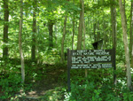
Adams Lake State Park
Trail Map
Appalachia
Discovery Birding Trail
www.appalachiandiscovery.com
Appalachia
Discovery Quilt Barn Trail
www.appalachiandiscovery.com
For more information on the
Quilt Barn Trail, visit our Quilt
Barn Squares page.
Brush
Creek State Forest
Visit
Site | E-mail Us | Locate
Us | Brochure
& Park Map (pdf) 15.22MB
 Located
in the unglaciated hill country
of south central Ohio, Brush Creek
State Forest was established in
1928 with the acquisition of 285
acres of land. This and other
early land acquisitions were originally
part of Shawnee State Forest.
As acreage and distances grew,
the need to form a separate state
forest unit became apparent in
order to properly manage these
scattered land holdings. Located
in the unglaciated hill country
of south central Ohio, Brush Creek
State Forest was established in
1928 with the acquisition of 285
acres of land. This and other
early land acquisitions were originally
part of Shawnee State Forest.
As acreage and distances grew,
the need to form a separate state
forest unit became apparent in
order to properly manage these
scattered land holdings.
In the early 1950s, a new state
forest was formed and drew its
name from a major stream in the
area known as Scioto Brush Creek.
A forest headquarters and service
center was established along State
Route 73 about one mile west of
the village of Rarden in western
Scioto County, and presently remains
at that site.
District
6 Forestry Office
Brush Creek State Forest
Shawnee State Forest
13291 U.S. Highway 52
West Portsmouth, OH 45663-8906
1-877-24STREE
Buckeye
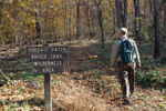
Trail
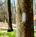 Follow
the Blue Blazes - For nearly
1444 miles, the Buckeye Trail
winds around Ohio, reaching into
every corner of the state. From
a beachhead on Lake Erie near
Cleveland, to an hilltop overlooking
the Ohio River in Cincinnati,
a hiker can experience a little
of all that Ohio has to offer.
Several sections of the Buckeye
Trail winds though Adams County,
please be sure to hike them all. Photo
from their website. Follow
the Blue Blazes - For nearly
1444 miles, the Buckeye Trail
winds around Ohio, reaching into
every corner of the state. From
a beachhead on Lake Erie near
Cleveland, to an hilltop overlooking
the Ohio River in Cincinnati,
a hiker can experience a little
of all that Ohio has to offer.
Several sections of the Buckeye
Trail winds though Adams County,
please be sure to hike them all. Photo
from their website.
1-800-OHIO200
www.buckeyetrail.org
Section
Trail maps
West
Union
Shawnee
Sinking
Springs
Chaparral
Prairie
Visit
Site | E-mail Us | Locate
Us | Trail Map
 A
blackjack-post oak prairie opening
with outstanding summer prairie
wildflowers and butterflies. This
is an outstanding cedar barren
prairie with post and blackjack
oak. It supports one of the most
extensive populations of rattlesnake-master
in the state. Prairie dock and
spiked blazing-star are also unusually
abundant at this site. Eleven
state-listed species have been
recorded from the preserve including
spider milkweed, prairie false
indigo, pink milkwort and Carolina
buckthorn. Little bluestem is
the dominant prairie grass. Several
rare lepidoptera, such as Edward's
hairstreak butterfly, have been
reported from this preserve. A
blackjack-post oak prairie opening
with outstanding summer prairie
wildflowers and butterflies. This
is an outstanding cedar barren
prairie with post and blackjack
oak. It supports one of the most
extensive populations of rattlesnake-master
in the state. Prairie dock and
spiked blazing-star are also unusually
abundant at this site. Eleven
state-listed species have been
recorded from the preserve including
spider milkweed, prairie false
indigo, pink milkwort and Carolina
buckthorn. Little bluestem is
the dominant prairie grass. Several
rare lepidoptera, such as Edward's
hairstreak butterfly, have been
reported from this preserve.
Hawk
Hill Road (Township Road 23)
West Union, OH 45693
Davis
Memorial State Nature Preserve
Visit
OHS Site | Visit
DNAP Site | E-mail Us | Locate
Us | Park
Map
 This
88-acre nature preserve, set in
an area of exceptional scenic
beauty, is of interest primarily
to geologists and botanists. The
preserve contains an impressive
geologic fault, dolomite cliffs,
a cave, and a diverse flora. There
are two richly forested hiking
trails. Diverse site with rare
species and excellent spring wildflowers.
Davis Memorial Preserve is an
outstanding geological as well
as botanical natural area. There
is a cave, Cedar Fork Cave, and
occasional sinkholes in the preserve
as well as excellent Silurian
dolomite cliffs. Both Greenfield
dolomite and Peebles dolomite
are exposed. Ohio black shale
occurs on the tops of the knobs.
An impressive fault, causing vertical
displacement of 30 feet, exposes
adjacent cliffs of Greenfield
and Peebles dolomite. A
classic sinkhole occurs along
the Buckeye Trail at the south
end of the preserve. The
dolomite cliffs provide habitat
for white cedars and sullivantia.
American aloe, dwarf hawthorn,
hairy wing-stem, side-oats gramma
grass and purple coneflower are
found in the prairie openings.
Other significant species present
include tall larkspur, limestone
Adder's-tongue fern, narrow-leaved
bluecurls and Walter's violet. Photo
from their website. This
88-acre nature preserve, set in
an area of exceptional scenic
beauty, is of interest primarily
to geologists and botanists. The
preserve contains an impressive
geologic fault, dolomite cliffs,
a cave, and a diverse flora. There
are two richly forested hiking
trails. Diverse site with rare
species and excellent spring wildflowers.
Davis Memorial Preserve is an
outstanding geological as well
as botanical natural area. There
is a cave, Cedar Fork Cave, and
occasional sinkholes in the preserve
as well as excellent Silurian
dolomite cliffs. Both Greenfield
dolomite and Peebles dolomite
are exposed. Ohio black shale
occurs on the tops of the knobs.
An impressive fault, causing vertical
displacement of 30 feet, exposes
adjacent cliffs of Greenfield
and Peebles dolomite. A
classic sinkhole occurs along
the Buckeye Trail at the south
end of the preserve. The
dolomite cliffs provide habitat
for white cedars and sullivantia.
American aloe, dwarf hawthorn,
hairy wing-stem, side-oats gramma
grass and purple coneflower are
found in the prairie openings.
Other significant species present
include tall larkspur, limestone
Adder's-tongue fern, narrow-leaved
bluecurls and Walter's violet. Photo
from their website.
Davis
Memorial Rd
Peebles, OH 45660
The
Edge of Appalachia Preserve System
Visit
Site 1 | Visit
Site 2 | PDF Trail Map | PDF Brochure |
 Amid
rocky slopes, rolling meadows
and deep moist ravines, relict
plant communities have persisted
for thousands of years. The Ohio
chapter of The Nature Conservancy
and the Museum of Natural History
& Science at Cincinnati Museum
Center own and manage a series
of 10 nearly contiguous preserves,
collectively called The Richard
and Lucile Durrell Edge of Appalachia
Preserve System, the largest privately
owned protected natural area in
Ohio. The
Edge of Appalachia provides critical
habitat for some 100 rare species
of plants and animals. Four areas
in the preserve, Lynx Prairie,
Buzzardroost Rock, Red Rock and
the Wilderness, are registered
National Natural Landmarks, testimony
to their national significance.
The eminent ecologist E. Lucy
Braun first called attention to
the biodiversity of "The
Edge" in the 1920s. Her students,
Richard and Lucile Durrell, were
early leaders in the effort to
preserve this outstanding natural
area. Amid
rocky slopes, rolling meadows
and deep moist ravines, relict
plant communities have persisted
for thousands of years. The Ohio
chapter of The Nature Conservancy
and the Museum of Natural History
& Science at Cincinnati Museum
Center own and manage a series
of 10 nearly contiguous preserves,
collectively called The Richard
and Lucile Durrell Edge of Appalachia
Preserve System, the largest privately
owned protected natural area in
Ohio. The
Edge of Appalachia provides critical
habitat for some 100 rare species
of plants and animals. Four areas
in the preserve, Lynx Prairie,
Buzzardroost Rock, Red Rock and
the Wilderness, are registered
National Natural Landmarks, testimony
to their national significance.
The eminent ecologist E. Lucy
Braun first called attention to
the biodiversity of "The
Edge" in the 1920s. Her students,
Richard and Lucile Durrell, were
early leaders in the effort to
preserve this outstanding natural
area.
Leran about the
Edge of Appalachia Preserve System's new Eulett
Center. Download a PDF on the Eulett Center
937-544-2880
Waggoner
Riffle Rd
West Union, OH 45693
Johnson
Ridge
Visit
Site | E-mail Us | Locate
Us
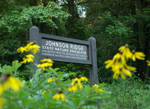 208
acres of wilderness with summer
prairie wildflowers. The preserve
sets alongside an Amish community. 208
acres of wilderness with summer
prairie wildflowers. The preserve
sets alongside an Amish community.
Unity
Rd
West Union, OH 45693
North Country Trail
(866) 445-3628
Info on
Ohio section (including Adams County).
Ohio
River Scenic By-way
Map
of the Ohio section
Robert
A. Whipple State Nature Preserve
Visit
Site | E-mail Us | Locate
Us
 270
acres filled with Dolomite cliffs,
slump blocks and sinkholes; good
spring wildflowers. Pull off parking
and a sign are present. 270
acres filled with Dolomite cliffs,
slump blocks and sinkholes; good
spring wildflowers. Pull off parking
and a sign are present.
NEW - 2 miles of moderate Hiking
Trails!
The
east side of St Rt 247, approximately
1 mile north of Rt
52
Manchester, OH 45144
Shawnee
State Forest
Forest
Site | Park
Site | Conference
Center | Trail Map
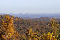 From
their website - Located in
the Appalachian foothills near
the banks of the Ohio River, Shawnee
State Park is nestled in the 63,000-acre
Shawnee State Forest. From
their website - Located in
the Appalachian foothills near
the banks of the Ohio River, Shawnee
State Park is nestled in the 63,000-acre
Shawnee State Forest.
Once
the hunting grounds of the Shawnee
Indians, the region is one of
the most picturesque in the state,
featuring erosion-carved valleys
and wooded hills. The rugged beauty
of the area has earned it the
nickname "The Little Smokies." Setting along the boarder
of Adams & Scioto Counties.
Park
Office
4404 State Route 125
Portsmouth, Ohio 45663-9003
Forestry 740-858-6685
Park Office 740-858-6652
Golf Course 740-858-6681
Campground (seasonal) 740-858-4561
Campground Reservations 866-644-6727
Resort Lodge 740-858-6621
Lodge Front Desk Fax 740-858-4766
Lodge and cottage Reservations
800-828-7275
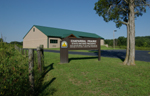
Shoemaker State Nature Preserve
Visit
Site |
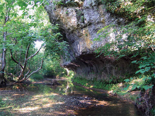 Adams County's newest preserve featuring natural arches, dolomite cliffs and slump blocks. This preserve protects a tributary of the Scioto Brush Creek and includes a 1.5mile hiking trail. Adams County's newest preserve featuring natural arches, dolomite cliffs and slump blocks. This preserve protects a tributary of the Scioto Brush Creek and includes a 1.5mile hiking trail.
165 Pine Gap Rd
Peebles, OH 45660
Tranquility
Wildlife Area
Visit
Site | Map
(pdf 388KB)
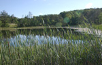 "Tranquility
Wildlife Area is located 16 miles
south of Hillsboro on State Route
770. County Road 100 (Old State
Route 32) runs along the southern
boundary of the area." Learn
More... "Tranquility
Wildlife Area is located 16 miles
south of Hillsboro on State Route
770. County Road 100 (Old State
Route 32) runs along the southern
boundary of the area." Learn
More...
St
Rt 770 & Old St Rt 32
Seaman & Peebles, OH 45660
|