|
Boating,
Canoeing, Creekin’, Fishing...
 Adams
County, Ohio is blessed with many
different ways to enjoy nature
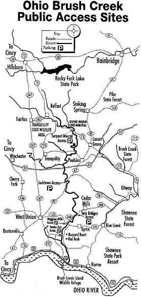
and water. The Ohio Brush Creek
snakes it's way through the county
to join the magnificent Ohio River.
Along the way there are several
public access points. At these
points one can drop in a canoe,
boat, inter tube, yourself, or
a fishing line. One can also go
creekin', just walk along the
stream exploring. Brush Creek
is mostly limestone and houses
loads of fossils. One fun spot
is off 247 South out of West Union
at the bridge next to Moores Run
Rd. Adams
County, Ohio is blessed with many
different ways to enjoy nature
and water. The Ohio Brush Creek
snakes it's way through the county
to join the magnificent Ohio River.
Along the way there are several
public access points. At these
points one can drop in a canoe,
boat, inter tube, yourself, or
a fishing line. One can also go
creekin', just walk along the
stream exploring. Brush Creek
is mostly limestone and houses
loads of fossils. One fun spot
is off 247 South out of West Union
at the bridge next to Moores Run
Rd.
The entire southern edge of our
County boarders the Ohio River,
with several boat launches along
US 52.
There
are several lakes and pond to
fish and swim in.
You
can also check out the Ohio
DNR Div. of Watercraft: River
& Stream Access / South Central
/ Ohio Brush Creek.
Boating
Adams
Lake State Park & Prairie
Visit
Site | Park
Map
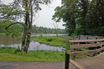 Located
in Ohio's Bluegrass region, one
of the state's most scenic and
biologically interesting areas,
Adams Lake State Park has much
to offer the nature enthusiast.
Remnant prairies and a quiet lake
can be enjoyed in this small unique
park. Only non-powered craft and
those with electric motors only
are permitted on the lake. A small
launch ramp near the park entrance
provides access to the 47-acre
lake. Only
non-powered craft and those with
electric motors only are permitted
on the lake. A small launch ramp
near the park entrance provides
access to the 47-acre lake. An accessible 3/4-mile
walking path follows the southern
shore of the lake. Additional
trails at Adams Lake are found
on the adjacent
prairie maintained by the ODNR
Division of Natural Areas and
Preserves. Due to the botanical
uniqueness of this area, visitors
are not permitted to wander from
the established trails. Questions
about the prairie or its rules
should be directed to the preserve
manager at (513) 544-9750. Picnic tables and
restrooms are located throughout
the park. A picnic shelter is
available by reservation, call
(740) 858-4561. Playground facilities
are also available. Located
in Ohio's Bluegrass region, one
of the state's most scenic and
biologically interesting areas,
Adams Lake State Park has much
to offer the nature enthusiast.
Remnant prairies and a quiet lake
can be enjoyed in this small unique
park. Only non-powered craft and
those with electric motors only
are permitted on the lake. A small
launch ramp near the park entrance
provides access to the 47-acre
lake. Only
non-powered craft and those with
electric motors only are permitted
on the lake. A small launch ramp
near the park entrance provides
access to the 47-acre lake. An accessible 3/4-mile
walking path follows the southern
shore of the lake. Additional
trails at Adams Lake are found
on the adjacent
prairie maintained by the ODNR
Division of Natural Areas and
Preserves. Due to the botanical
uniqueness of this area, visitors
are not permitted to wander from
the established trails. Questions
about the prairie or its rules
should be directed to the preserve
manager at (513) 544-9750. Picnic tables and
restrooms are located throughout
the park. A picnic shelter is
available by reservation, call
(740) 858-4561. Playground facilities
are also available.
LOCATION:
14633 STATE ROUTE 41
West Union, OH 45693
CONTACT:
Shawnee State Park
4404 State Route 125
Portsmouth, OH 45663-9003
(740) 858-6652 Shawnee State Park
Brush
Creek Campground & Boat Ramp
Visit
Site | E-mail Us |
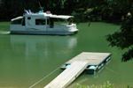 Ohio River &
Ohio Brush Creek - unlimited boating,
launch ramp fee, camping, island,
food, bait, picnic areas, showers,
overnight docking, and fuel. Government
built public boat landing. Season
is April through September.....weather
and river permitting.
Ohio River &
Ohio Brush Creek - unlimited boating,
launch ramp fee, camping, island,
food, bait, picnic areas, showers,
overnight docking, and fuel. Government
built public boat landing. Season
is April through September.....weather
and river permitting.
937-549-3380
17085
US 52 at Brush Creek
Manchester, OH 45144
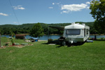
Sandy
Springs Campground
Visit
Site | E-mail Us |
 40 new campsiteslocated
along the banks of the scenic
OhioRiver just south of the small
village of Sandy Springs on US
52 (Scenic Byway) Tent camping
and full hookup for RVs, restrooms
& showers, 30/50 amp hookups.
Daily, monthly, & seasonal
rates. Primitive gravel ramp for
small boat launching.
40 new campsiteslocated
along the banks of the scenic
OhioRiver just south of the small
village of Sandy Springs on US
52 (Scenic Byway) Tent camping
and full hookup for RVs, restrooms
& showers, 30/50 amp hookups.
Daily, monthly, & seasonal
rates. Primitive gravel ramp for
small boat launching.
740-464-8092
or 740-464-8748
US 52
Sandy Springs, OH
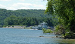
Island
Creek Marina and Campground
Visit
Site | E-mail Us |
 Home of the Island
Creek Mound, an unexcavated Woodland
era Native American mound just
north east of the parking lot.
Camp among history along the beautiful
shore of the Ohio River, which
over looks one of the Manchester
Islands. Enjoy hours of bird watching
or unlimited boating via the public
boat launch ramp.
Home of the Island
Creek Mound, an unexcavated Woodland
era Native American mound just
north east of the parking lot.
Camp among history along the beautiful
shore of the Ohio River, which
over looks one of the Manchester
Islands. Enjoy hours of bird watching
or unlimited boating via the public
boat launch ramp.
937-549-1430
8801
US 52
Manchester, OH 45144
Kinfolk
Landing - Ohio River
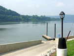 Manchester's
boating ramp to the Ohio River.
The Ohio River is 981 miles long,
starting at the confluence of
the Allegheny & the Monongahela
Rivers in Pittsburgh, PA, and
ending in Cairo, IL, where it
flows into the Mississippi River.
The Ohio river offers approximately
164 species of fish to the avid
angler. During the Summer and
Fall months large Paddlewheelers
travel the river. Manchester's
boating ramp to the Ohio River.
The Ohio River is 981 miles long,
starting at the confluence of
the Allegheny & the Monongahela
Rivers in Pittsburgh, PA, and
ending in Cairo, IL, where it
flows into the Mississippi River.
The Ohio river offers approximately
164 species of fish to the avid
angler. During the Summer and
Fall months large Paddlewheelers
travel the river.
Follow
the signs from Rt 52
Manchester, OH 45144
Tranquility
Wildlife Area
Visit
Site | | Map
(pdf 388KB)
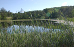 "Tranquility
Wildlife Area is located 16 miles
south of Hillsboro on State Route
770. County Road 100 (Old State
Route 32) runs along the southern
boundary of the area." Learn
More...
"Tranquility
Wildlife Area is located 16 miles
south of Hillsboro on State Route
770. County Road 100 (Old State
Route 32) runs along the southern
boundary of the area." Learn
More...
Largemouth
bass and bluegill are the principal
species of fish stocked in ponds
on this area and good catches
of both are reported.
St
Rt 770 & Old St Rt 32
Seaman & Peebles, OH 45660
Live
Bait Shops
Brushcreek
Campgrounds, 17085 US 52 at Brush
Creek, Manchester
Cabin Fever,104 N Main St, Peebles,
937-587-1100
Trail
& Arrow, 13726 St Rt 136,
Cherry Fork, 937-695-0278
Walmart,
11217 St Rt 41, West Union, 937-544-7198
Wildlife
Ohio
River Island National Wildlife
Refuge
Visit
Site | E-mail Us | Locate
Us
 From their web
site...
From their web
site...
The Ohio River Islands National
Wildlife Refuge conserves the
"wild Ohio" within one
of our nation's busiest inland
waterways. Established in 1990,
the refuge extends along 362 miles
of the upper Ohio River with 22
scattered islands and three mainland
properties. The refuge works to
protect wildlife and habitats
native to the Ohio River and its
floodplain. Migratory birds and
endangered freshwater mussels
are among the important wildlife
emphasized on the refuge.
The two Manchester
Islands are apart of this refuge
They are numbers 22 & 23 on
their map.
The
Manchester Islands are located
across from Island
Creek Marina and Campground
8801
US 52
Manchester,
OH 45144
For
more information on ORINWR contact:
Ohio River Island NWR
3982 Waverly Rd
Williamstown, WV 26187
304-375-2923
|